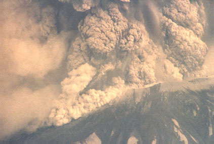
In 1980, Troy Adamson was fifteen years old. When Mt. St. Helens blew Troy went with his dad in their plane and flew 10 miles from the mountain when Troy took this picture of the eruption. If you look closely you will notice an aircraft against the ash plume in the center of the image.

The blast of hot ash and gasses from Mount St. Helens traveled at hundreds of miles per hour, leveling 230 square miles of mature forest triggered the largest landslide in recorded history. The ash cloud reached a height of 15 miles and, when visibility cleared, the mountain was 1,300 feet shorter. You can view the crater from the northern highway that ends up at the Coldwater Ridge Observatory. The observatory has a working model or diorama of the mountain where you can see exactly just how the mountain erupted. When you leave the observatory you can walk up and look directly into the crater. (If it is permissible.) It is an eerie place where the wind seems to be constantly blowing and the gasses and steam still rise from the crater. Everything is sort of gray but the floor of the forest is starting to show signs of growth. You will see the giant forest of trees disrupted from the blast; the tree leaves and limbs completely disappeared, the trees laid in formation from the blast all with their trunks pointed towards the crater. Just off the highway on your right as you enter the blast zone you will notice an A frame house. Upon closer inspection you will notice the ash has entered the first floor filling the kitchen sink and the room. After the ash settles for a while it becomes hard like concrete. There are many observation lookouts and 2 other observatories or information centers once you leave Interstate 5. At one lookout above the Tuttle River we watched through the viewing scope provided, a herd of elk wandering around below by the river. The bed of the river was lush and green in color.
Return to Church History 1980